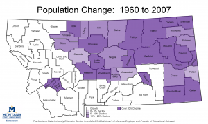
Montana has been growing a remarkably steady rate of approximately 0.8% per year over the past 50 years. This growth has not been evenly distributed across the state. A net total growth of approximately 369,000 people was observed from 1960 to 2016. Six counties (Yellowstone, Gallatin, Missoula, Flathead, Lewis & Clark, and Ravalli) experienced the bulk of the growth with a combine population growth of over 363,000. Montana also has long-term trend of population moving away from northern and eastern parts of the state and moving toward western and south central Montana. Over the same time period, 31 counties lost a combined 66,000 residents. This trend is easily visualized in this map of population changes from 1960 to 2007 (growth areas are represented in white). You’ll notice with the exception of Silver Bow and Deer Lodge counties in the west, the population shifts are basically defined by a two contiguous geographic regions.

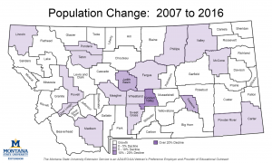
Over the past decade this long term trend does not appear to be continuing. Population gains on the parts of highline, in the northeast corner and the Bakken region are shifts from the longer term trends.

Montana had 32 counties lose population from 1960 to 2007. 20 of these counties experienced population growth over the past 10 years, while 12 continued to lose population. Montana also had 24 counties gain population from 1960 to 2007. Three of these previously growing counties (Lincoln, Madison and Powell) lost population over the past 10 years. Maybe this signals the start of a new long term trend or maybe the past decade was a bit of an anomaly.
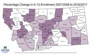
Another way to get a peek at the future population is to look at k-12 public school enrollment. Here we see that the growth areas are not as widespread as population growth have been but we see a growth patterns that are not aligned along the North Central and East vs. Western and South Central areas. This this past decade has been a change from longer term trends, the next question is what the upcoming decade will look like.


